Good Morning. This is Doug Chabot with the Gallatin National Forest Avalanche Forecast on Thursday, January 30th at 7:00 a.m. Today’s forecast is sponsored by Swiss Fit Montana and Ph.D. Skis. This forecast does not apply to operating ski areas.
At 5 a.m. the mountains picked up 1-2” overnight with temperatures in the high teens and westerly winds averaging 15 mph and gusting to 35 mph. Skies will clear by this afternoon as winds taper and temperatures rise to the mid-30s. Clouds will roll in tonight and a small shot of snow is expected tomorrow.
All Regions
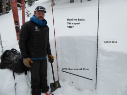
Over the last two days 4-6” has fallen over our forecast area. This is not enough snow to increase the avalanche danger, but is enough to keep us on our toes. We have a weak layer of sugary snow near the ground that continues to exhibit instability. Monday’s large snow storm in the Bridger Range (7” of very dense snow) was enough to trigger a 5-10’ deep avalanche on Naya Nuki Peak (photo). Since then, natural avalanches have not been seen, but stability tests are breaking on this layer, a warning that human-triggered avalanches are not out of the question. On Tuesday, Ian and I saw this in Beehive Basin (photo, video), Dave had the same on Buck Ridge (video), and sledders and skiers in Taylor Fork and Hyalite also got this layer to release in their tests.
The Lionhead area and the mountains around Cooke City have been quiet with no recent avalanche activity, cracking or collapsing. However, the weak layer of sugary facets is buried deep in these mountains and still breaking in tests last weekend in Cooke City. These results gives me slight pause even though the stability trend is positive.
In the absence of visual clues that slopes are unstable (avalanches or “whumphs”) we rely on digging to get the information we need. If you are heading onto a steep slope perform a stability test as one last step in your assessment before committing. I’m a fan of the Extended Column Test. If the column breaks clean, at the very least it will instigate a robust discussion with your partners, and might even change your plans.
For today, avalanches are still possible and the danger is rated MODERATE. Additionally, wet, loose snow avalanches might sluff off steep slopes getting baked by the sun.
If you get out, please send us your observations no matter how brief. You can fill out an observation form, email us (mtavalanche@gmail.com), leave a VM at 406-587-6984, or Instagram (#gnfacobs).
King and Queen of the Ridge at Bridger Bowl
This Saturday, February 1, is the King and Queen of the Ridge at Bridger Bowl! Come up and help us raise money by hiking and skiing laps on the ridge. Prizes, camaraderie and a good time are guaranteed. Register with Bridger to hike in the event and create a pledge page to raise funds with your Ridge laps.
Upcoming Avalanche Education and Events
Our education calendar is full of awareness lectures and field courses. Check it out and plan to attend one or two: Events and Education Calendar.
COOKE CITY
Every Friday and Saturday, Snowpack Update and Rescue Training. Friday, 6:30-7:30 p.m. at the Soda Butte Lodge. Saturday anytime between 10-2 @ Round Lake.
BOZEMAN
February 1, King and Queen of the Ridge at Bridger Bowl (fundraiser). This is the Friends of the Avalanche Center’s second biggest fundraiser of the year. Help us raise money by hiking and skiing laps on the ridge. Prizes, camaraderie and a good time are guaranteed. Register with Bridger to hike in the event, and create a pledge page to raise funds with your Ridge laps.
WEST YELLOWSTONE
February 1, 1-hr Avalanche Awareness, 7-8 p.m. at West Yellowstone Holiday Inn.
See our mid-season snowpack summary for a review of the deep slab avalanche problem and general (conservative) travel advice.


