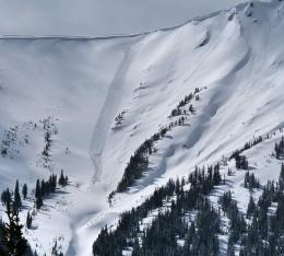
Good Morning. This is Doug Chabot with the Gallatin National Forest Avalanche Forecast on Thursday, March 19th at 7:15 a.m. Spring officially begins at 9:49 p.m. tonight, so enjoy your last day of winter! Today’s forecast is sponsored by Spark R&D and Swiss Fit Montana.
* Ski Areas are closed for the season. Backcountry conditions exist. There is no avalanche control or ski patrol services. Please stay clear of workers, work areas, snowcats, snowmobiles, chair lifts and other equipment. Watch Dave’s video explaining what to expect if you tour in the ski area.
Yesterday, Cooke City picked up 5” of snow while everywhere else got a trace to 1”. Wind is light from the west to north and temperatures at 5 a.m. are 20F under cloudy skies. Temperatures will not rise more than a few degrees above freezing and skies will be mostly cloudy, except Cooke City which may get sun. There may be a few lingering snow showers this morning, but no accumulation is expected. The next few days will be sunny and warm.
The mountains around Cooke City picked up 5” in the last 24 hours. Over 2 feet of snow measuring 2” of snow water equivalent has fallen since Sunday. Winds have been unusually light. Our main concern is the new and old snow interface since Tuesday when a layer of surface hoar crystals (feathers of snow) was formed. Yesterday, skiers found it on slopes that remained shady (north facing) in the Fisher, Miller and Wolverine areas. Shooting cracks are a sign that it is underfoot and could avalanche. In the absence of cracking, it’s a good idea to dig with your hand a few inches under the surface to see if it’s there. On many slopes a buried ice crust is allowing new, loose snow avalanches to travel far. Given yesterday’s snow, a buried weak layer scattered about, and the potential for sunny skies and melting snow, the avalanche danger is rated MODERATE since avalanches are possible today.
From the Bridger Range to West Yellowstone, the mountains received up to an inch of new snow with calm to light wind. Today will be mostly cloudy, temperatures will be cool and wet avalanches will be an afterthought. In general the snowpack is stable. Slopes that have received sun and melting earlier in the week have an ice crust a few inches under the surface (photo). Skiers on Hardscabble Peak in the Bridger Range were able to sluff the new snow on this crust. I was in Bacon Rind yesterday and found relatively stable snow and noted how the ice crusts will help avalanches slide far when the snow gets wet in the coming days (video).
A thin layer of surface hoar was formed on Tuesday, before the most recent snow, in Hyalite, Beehive and near Big Sky. These are the areas we know of. These feathery crystals (photo) make a persistent weak layer that will be seen as a stripe in the snow. We are still determining if they survived burial and if they will become a problem. Drop us a line if you find them.
For today, avalanches are unlikely and the danger is rated LOW. If, contrary to the weather forecast, the sun appears and wets the surface snow, the wet snow avalanche danger will rise accordingly.
If you get out, please send us your observations no matter how brief. You can fill out an observation form, email us (mtavalanche@gmail.com), leave a VM at 406-587-6984, or Instagram (#gnfacobs).
Upcoming Avalanche Education and Events
The GNFAC and Friends avalanche education programs have been cancelled due to the coronavirus. Thank you to all our amazing instructors for a great year of education!
Our education calendar lists awareness lectures and field courses offered by other providers: Events and Education Calendar.
On Sunday, March 15, a sidecountry skier was killed in an avalanche out of bounds at the Pebble Creek Ski area south of Pocatello, Idaho. The Utah Avalanche Center visited the site and along with the Sawtooth Avalanche Center, will publish a report soon. This is the 19 avalanche fatality of the winter.


