Good morning. This is Doug Chabot with the Gallatin National Forest Avalanche Forecast on Thursday, March 9th at 7:00 a.m. This information is sponsored by Pine Edge Cabins, FUGOWEE Snowmobile Club and Gallatin Valley Snowmobile Association. This forecast does not apply to operating ski areas.
At 5 a.m. there is 1” of new snow in Cooke City and 2-3” in Big Sky to West Yellowstone. Wind is 5-15 mph from the S-SW, with the exception being the Bridger Range where an east wind is blowing 20-30 mph. Temperatures are 0-5F. Today will be partly cloudy and light wind with temperatures reaching the high teens. Snowfall late tonight will drop an inch up north and 3” in the southern ranges.
Two days in a row of sun was a nice change of pace from steady snowfall. Last night’s .1-.2” of snow water equivalent (SWE) in Big Sky to West Yellowstone, along with diminishing wind, will not adversely affect the snow stability. Weak layers of faceted snow and surface hoar will be less sensitive to triggering today, but it would be foolhardy to forget about them.
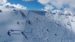
Yesterday, gusty wind made a few wind slabs that were naturally triggered in Hyalite and were seen in Cooke City. On Tuesday, Ian and I rode upon a freshly triggered 3-foot deep avalanche in Lionhead that was underneath a cornice that broke on a buried weak layer (video). Last week’s large avalanches were a stark reminder that “old” weak layers, like the surface hoar that was buried January 8, can come alive with enough of a load. Every layer has a breaking point. In Cooke City I measured 11” of SWE on this layer (conservatively, that’s 11 feet of snow) in the crown of a skier triggered avalanche (video). In Hyalite, Dave measured over 8” of SWE in a large avalanche that caught and partially buried a skier (video). And yesterday in Bacon Rind (video), my partner and I measured 4” of SWE above the surface hoar in a snowpack that had good stability…good because it was not loaded with double or triple the water weight we found in Cooke or Hyalite. We do not expect you to measure the SWE, but I mention it to illustrate how heavy loads can breathe life into seemingly forgotten weak layers.
Deep, hard slab avalanches are vicious. My palms sweat thinking about triggering one. These are low probability, high consequence avalanches, a description you will hear often as we describe this Deep Slab problem. More likely today are avalanches involving wind-drifted snow or recently buried weak layers in the upper foot of the snowpack, which Dave found in Hyalite.
What to do: 1. Avoid wind-loaded slopes, 2. Dig and see if there’s a new weak layer in the top 1-2 feet of the snowpack, and 3. Think about staying out of steep terrain in areas that have 7+ feet of snow.
Triggering avalanches remain possible and the avalanche danger is rated MODERATE.
Please share avalanche, snowpack or weather observations via our website, email (mtavalanche@gmail.com), phone (406-587-6984), or Instagram (#gnfacobs).
Throughout our forecast area we are mostly concerned about triggering avalanches in wind-drifted snow near the ridgelines or on recently buried weak layers in the upper foot of the snowpack. On slopes that have 7 feet or more of snow, a deeply buried weak layer could result in a low probability, high consequence avalanche, a scary proposition. Triggering avalanches remain possible.
Upcoming Avalanche Education and Events
Our education calendar is full of awareness lectures and field courses. Check it out: Events and Education Calendar.
TONIGHT! 6 p.m.-7 p.m., 1-Hour Awareness - Spring conditions. FREE at REI Bozeman.
TOMORROW! March 10 & 11, SheJumps - Women’s Companion Rescue Clinic. Online classroom session Friday evening followed by a field session from 10 a.m.-2 p.m. Saturday. More information and registration HERE.
Every Saturday, 10 a.m. - 2:00 p.m. Avalanche Rescue Training, drop in for any amount of time. Round Lake Warming Hut, Cooke City. Free.
Loss in the Outdoors is a support group for those affected by grief and loss related to outdoor pursuits. Check out the link for more information.
A list of all avalanche activity from our forecast area can be viewed HERE.


