This is Alex Marienthal with the avalanche forecast for Sunday, March 9th, at 7:00 a.m. sponsored by World Boards and Spark R&D. This forecast does not apply to operating ski areas.
This morning, under mostly clear skies, temperatures are teens to low 30s F, and wind is out of the west at 5-15 mph with gusts to 35 mph.
Today, temperatures will reach high 30s to low 40s F under mostly sunny skies, and wind will remain light to moderate from the west and southwest at 5-15 mph with gusts to 35 mph.
Over the next few days cloud cover will increase with slightly cooler temperatures. Tomorrow night there is a chance for light snow showers with more snow possible late Wednesday through next weekend.

Today the primary avalanche problem is wind slab avalanches where 5-7” of snow from Thursday was drifted into stiffer slabs. These drifts were reactive and easily triggered the last couple days. Yesterday in the northern Bridgers skiers triggered a few wind slabs that were 8-10” deep and 10-20’ wide. One person was caught and carried ten feet (details and photos). Two days ago Ian and I found similar fresh drifts that easily cracked under our skis (photo, photo, video).
Above freezing temperatures and sunny skies will make wet loose avalanches a concern later in the day. These will probably be small, but could easily knock over a person. Watch and feel for a wet or moist snow surface to indicate you could trigger shallow loose snow slides, and anticipate this hazard to develop mostly around rock outcrops on slopes that receive direct sunshine.
Remain cautious of travel on steep wind-loaded slopes and steep sunny slopes today, especially above cliffs, rocks or thick trees where even a smaller slide would be more dangerous.
Near West Yellowstone and the southern Madison and Gallatin ranges an additional concern is Persistent Slab avalanches breaking 2-3’ deep on weak layers buried in late January. The last of these deeper avalanches were over a week ago (photo). The likelihood has decreased, but the size would be big enough to have serious consequences. These slides were mostly on mid-elevation slopes with trees around and have surprised riders, leading to several close calls (Lionhead, Cabin Creek). Travel one person at a time across steep slopes and have a partner watching from a safe spot. If you ride steeper slopes, choose terrain with minimal trees, rocks, cliffs or confined gullies.
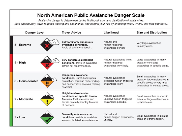
The avalanche danger is MODERATE.

Cooke City got less new snow last week, so the likelihood and size of potential avalanches is smaller. Wind slab avalanches and wet loose avalanches are a concern, but their size will be small and distribution is minimal. Avalanches breaking deeper on buried weak layers are unlikely. The last of these persistent slab avalanches were a couple weeks ago (details), and were the only slides of this type near Cooke City over the last couple months.
While the snowpack is generally stable, you should follow standard safe protocols for travel in avalanche terrain. Expose only one person at a time to steep slopes and carry proper rescue gear (transceiver, probe and shovel). Stay alert for recent drifts and wet loose avalanches, especially in terrain where a small slide has higher consequences. The avalanche danger is LOW near Cooke City.
Upcoming Avalanche Education and Events
Our education calendar is full of awareness lectures and field courses. Check it out: Events and Education Calendar
Avalanche awareness focused on springtime avalanche conditions: Thursday, March 13 at the Bozeman REI from 6-7:30 p.m. The event is free but has limited space and requires registration HERE.