Good Morning. This is Dave Zinn with the Gallatin National Forest Avalanche Forecast on Tuesday, January 12th at 7:15 a.m. This forecast is sponsored by Alpine Orthopedics & Sports Medicine and Yellowstone Ski Tours. This forecast does not apply to operating ski areas.
Mountain temperatures this morning are in the teens to mid-20s F with 15-25 mph wind from the southwest to northwest and there is no new snow. Clouds will increase through the day with temperatures reaching the 20s F in the southern ranges and 30s F in the northern ranges. The wind will blow 15-25 mph from the southwest and we will have a trace to 1” of new snow by morning.
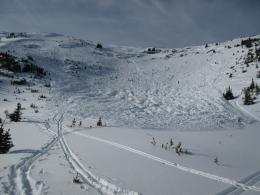
The snowpack in the Bridger, Madison, Gallatin, and Lionhead Ranges consists of a widespread and persistent layer of weak, sugary facets capped by a thick slab of more cohesive snow. This is a dangerous setup with many recent avalanches and red flag indicators of an unstable snowpack. Some highlights from the last week include a very large, skier-triggered avalanche on Flanders Mountain on Saturday that Alex investigated yesterday (video), an avalanche in Cinnamon Creek that skiers triggered from across a meadow (photo), and a 1000’ wide snowmobile-triggered avalanche near Buck Ridge (video). Yesterday, the Football Field immediately south of the Bridger Bowl avalanched for the second time this season clearly demonstrating that once slopes are reloaded after an avalanche they are once again suspect (details and photo). For a full recap of all recent avalanche activity visit the avalanche activity log on our website.
Four days have passed since the last new load of snow and avalanches are less likely, but triggering a large slide remains a dangerous possibility. When persistent weak layers are in play, your forecasters play it safe by limiting our exposure to steep slopes. On my field day in the Bridger Range yesterday, heavily wind-drifted slopes were the most suspect (video).
The avalanche danger is rated MODERATE. Careful snowpack assessment and cautious route selection are essential if you intend to travel on, underneath or adjacent to steep slopes.
The situation in Cooke City is more complicated. Persistent weak layers exist on some slopes and avalanches are breaking 1.5-2’ deep including a nearly fatal slide on the Fin on Friday and several human-triggered and natural avalanches on Saturday (accident report, video, details 1, 2, 3). The weak layer is not universally distributed, and many slopes are stable. The easy way to avoid avalanches is to stay out of steep terrain thus eliminating the negative consequences of accidentally finding a slope with weak snow. However, if you want to ride or ski in avalanche terrain without rolling the dice you must carefully assess for instabilities in the top 3’ of the snowpack. Pay special attention to relatively shallow areas and wind-loaded slopes. Today, avalanches are possible and avalanche danger is rated MODERATE.
If you get out, please send us your observations no matter how brief. You can submit them via our website, email (mtavalanche@gmail.com), phone (406-587-6984), or Instagram (#gnfacobs).
Upcoming Avalanche Education and Events
See our education calendar for an up-to-date list of all local classes. Here are a few select upcoming events and opportunities to check out:
Every Saturday in Cooke City, FREE snowpack update and rescue practice at the Round Lake Warming Hut between 10 a.m. and 3 p.m. Poster with More Info.
January 15 and 16, Companion Rescue Clinic, 6-8pm Friday Zoom online, Saturday field session 10am - 2pm. Register HERE.
Tuesday, January 19, 6-7 p.m. The Friends of the Avalanche Center will offer a FREE 1-hr Avalanche Awareness Talk in partnership with the University of Montana Western School of Outreach. The talk will be a live, ONLINE event. Join us HERE.
January 20 & 21 (plus field sessions the following weekends), Avalanche Fundamentals with Field Course. There are separate field sessions tailored for both skiers and splitboarders (Bridger Bowl) and snowmobilers (Buck Ridge). Register here.
On Friday, a snowboarder died in an avalanche near Park City, Utah. The rider was not carrying any rescue gear. Our thoughts are with those affected by this tragic accident. A preliminary report is here.


