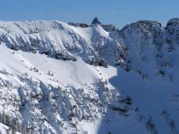
Good Morning. This is Dave Zinn with the Gallatin National Forest Avalanche Forecast on Wednesday, January 13th at 7:15 a.m. This forecast is sponsored by Cooke City Super 8/Bearclaw Bob’s and Knoff Group Real Estate. This forecast does not apply to operating ski areas.
Bozeman’s mountains received 1” of new snow in the last 24 hours. Cooke City, Big Sky and West Yellowstone received 2-5” of snow with the Taylor Fork coming out on top. Winds in the Southern Madison and Gallatin Ranges through the Bridger Range are blowing 20-30 mph from the west to southwest. Winds in West Yellowstone and Cooke City are 5-10 mph from the southwest. Mountain temperatures are in the 30s F in the northern ranges and 20s F in the southern ranges.
Today, winds will be 30-40 mph in the northern ranges and 20-30 mph in the southern ranges from the southwest. Freezing levels start the day at 5000’ near West Yellowstone and 7000’ in the Bridger Range before dropping this afternoon. The mountains near Bozeman and Big Sky will get 1-3” of snow, 3-4” in West Yellowstone and 4-6” in Cooke City by morning.
Strong winds and new snow are increasing the likelihood of triggering an avalanche that breaks deeply on weak facets near the ground that exists from Lionhead through the Bridger Range. Stability decreased with 3-5” of new snow or 0.2-0.4” snow water equivalent (SWE) from Lionhead through Big Sky. The Bridger and Northern Gallatin Range have only received 1” or 0.1” SWE, but 20-30 mph winds with 60 mph gust are creating unstable drifts. Strong winds and precipitation will continue to decrease stability throughout the day.
Yesterday, Doug rode at Lionhead and saw many avalanches associated with last week’s storm (video) and I was at Bacon Rind observing a weak foundation that was still unstable four days after the last snowfall (video).
We are reentering a period of increased instability. Careful snowpack assessment and cautious route selection are essential to travel on, underneath or adjacent to steep slopes. Avoid wind-drifted slopes likely to avalanche under the weight of a rider or skier. The avalanche danger is CONSIDERABLE on wind-loaded slopes and MODERATE on non-wind-loaded. As snowfall continues, the avalanche danger will increase.
The mountains around Cooke City received 3” (0.3” of SWE) in the last 24 hours with more forecasted throughout the day. Persistent weak layers exist on some slopes that have resulted in avalanches breaking 1.5-2’ deep, but they do not exist on all. Skiers and riders are identifying this layer of weak snow within the top 3’ of the snowpack. Human triggered avalanches will become more likely as snow builds up today. Read our accident report from a nearly tragic avalanche on the Fin and look at photos on the website to get an idea of what these slides look like (video, details 1, 2, 3).
The avalanche danger is MODERATE and will increase as the storm adds weight and stress to the snowpack. Watch for signs of decreasing stability such as collapsing or “whumphing”, shooting cracks and new avalanches.
If you get out, please send us your observations no matter how brief. You can submit them via our website, email (mtavalanche@gmail.com), phone (406-587-6984), or Instagram (#gnfacobs).
Upcoming Avalanche Education and Events
See our education calendar for an up-to-date list of all local classes. Here are a few select upcoming events and opportunities to check out:
Every Saturday in Cooke City, FREE snowpack update and rescue practice at the Round Lake Warming Hut between 10 a.m. and 3 p.m. Poster with More Info.
January 15 and 16, Companion Rescue Clinic, 6-8pm Friday Zoom online, Saturday field session 10am - 2pm. Register HERE.
Tuesday, January 19, 6-7 p.m. The Friends of the Avalanche Center will offer a FREE 1-hr Avalanche Awareness Talk in partnership with the University of Montana Western School of Outreach. The talk will be a live, ONLINE event. Join us HERE.
January 20 & 21 (plus field sessions the following weekends), Avalanche Fundamentals with Field Course. There are separate field sessions tailored for both skiers and splitboarders (Bridger Bowl) and snowmobilers (Buck Ridge). Register here.
On Friday, a snowboarder died in an avalanche near Park City, Utah. The rider was not carrying any rescue gear. Our thoughts are with those affected by this tragic accident. A preliminary report is here.


